Genyen Inner Kora Trek – 9 days
from $1560
Genyen Outter Kora Trek – 9 days
from $1180
Traveled in October 2016, Alex Tang
After the busy travel time at the beginning of October in Western Sichuan things start to cool off from the second half. We set on this 2 week trip from Chengdu.
The drive took us in three days with nights stopped by Xinduqiao, Litang and then Batang. Sleeping at over 3000m in hotels help the acclimating.
 Batang in Garze
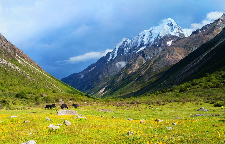
 Grassland North to Genyen
 Batang is bordering Tibet
This was an expedition trip aiming to explore the western part of Genyen Massif and for the climbers, to summit an unclimbed mountain below 6000m. It was a successful trip. All three climbers made summit to the 5625-m Xialong Rezha the first time ever. While the climbers are doing climbing, I got the chance to explore around the western part of the Genyen Massif.
Mid October in Western Sichuan is dry and you have possibly the best weather you could ask for. Not a single drop of rain or snow that we saw the whole trip. It was like the weather pattern from second half of Oct that one sees the blue sky and moderate temperature drop. It's still above 0 C degrees for most of the day only at night the temperature drops lower to below -5 or when it's later into October -10 and lower.
 From Batang to Genyen
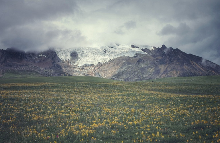
 Peaks of Genyen from West side
 Mt. Xialong Rezha NW
 Beautiful Village Daxiukuo
Daxiukuo is where we put an pin on a map and navigated towards to. It's the small village in the main valley of west Genyen. It was 3 hours drive from Batang in the Upper Yangtze Valley and over a 4800-m mountain pass on rugged road. This was my first time into here. Thinking about by driving you only get there on the fourth day from Chengdu: there are not many places in Sichuan where getting there from Chengdu by driving exceeds 3 days.
Daxiukuo is actually an old name of the village that we later found out it's known by the name of Gemu by now. There is also another Gemu in Litang(eastern part of Genyen) so this Gemu is called Gemu Daxiukuo. Daxiukuo is obviously the center of the valley despite it has only one full-time open shop that sells only ramen and cola. It has a primary school and also around 30 families living in Daxiukuo. There are more families living down the valley towards Bomi Village. We had a visit to the primary school there were around 200 kids there probably, all interested seeing outsiders.
 Daxiukuo is also called Gemu
 Old Monk in Daxiukuo
 Daxiukuo is by the base of Xialong Rezha
 Primary School in Daxiukuo
The river runs down the valley and goes all the way to Yangtze. Main roads have avoided here, making it somewhat isolated from the usual-seen Garze.
 Gemu Valley is the main valley in west Genyen
 Nomads Huts in Gemu Valley
The name of Xialong Rezha means "mountain of big rocks that has big horned animals" in Tibetan language. It's the first mountain you see when you drive down to the valley of Daxiukuo from Batang. Base camp is by the river junction below XR at 4200m. It's around 2 hour walk from the village of Daxiukuo. You can tell from there it's wild valleys and you only see deserted huts used by local nomads. There is a trail goes up the pass South to the base camp. East to the base camp is complete wild valleys.
From end of the village to the river junction it is only 5-6km. The village itself can be a base for further exploration around XR. The house we used is own by a monk, who actually told us the name of the mountain Xialong Rezha. The monk lives by himself and seems a cool monk, widely respected from around Daxiukuo. In Tibetan culture monks are educated people and the respected people. We got other more information of the mountains and valleys in Western Genyen from this monk.
 Mt. Xialong Rezha
 Fixing a Bridge
 Walk to BC of XR
 BC of XR
 BC of XR
 Nomads Village by the base of Chongban Halo
If you look at the Chongben Mountains from Google Earth you'll find a perfect pyramid mountain that is around 5500-m. These peaks are called Chongben Mountains(Chongben Halo, Chongben Haga ). Chongben mountains are located west to Daxiukuo by around half day's walking to get to its base. Over the pass one gets to Sanglongxi of Batang. The Chongben Mountains are three different rocky mountains with beautiful vertical rock faces. Locals regard these three mountains to be three brothers from local religion.
Two likely-to-be Himalayan wolves were spotted near Chongben Mountains. Til we realize we both had gone quote close to each other. Wolves were actually cool when it spotted me. We stared at each other for a minute or two and we both carried on. I was later confirmed and eased by local Tibetan guys that wolves here are harmless basically as long as you keep the distance. These two local guys come up here to tend their yaks and obviously they were riding a motorbike, indicating the path to the pass and down to Sanglongxi is okay.
 Cool Tibetan Guy
There are no records of the Chongben Mountains nor it's climbing. The name was from the local two Tibetan guys who have lived and traveled between Sanglongxi and Daxiukuo all the time. So its genuinity is convincing. When I walked up the pass it gets very close to the base of Chongben, from where you can tell its prominence is around maybe ??? Meters. Its rocky side looks amazing.
 Chongban Halo NE
 Chongben Mountains
 Chongben Mountains
 Chongben Mountains
 Himalayan Wolf
 Pass to Village Sanglongxi
Yangmolong Mountains are located by the Northwest to the massif of Genyen. It has the second highest mountain in this area at 6060m. The Yangmolong mountains have several peaks including Yangmolong(6060m), Makara (6033m), Laoche Zela(5833m) and two are prominent peaks that names are unknown.
Yangmolong is acctually the name of the pasture above Sanglongshi Village, a village by the North of the mountains. It is how people call the valley in general but not necessarily the mountain. According to villagers from Gemu, Mt. Yangmolong is called Emo Banga(mountain of white color), its side peak by its north (around 5650m) is called Emo Banla(mountain of black color). The 6033-m mountain is called Laoche Zela, different from the 5833-m Laoche Zela that appears in Nakamura's book. The 5833-m mountain is not so visible from Litang side so I guess from Batang side they should have a solid and reliable name.
Yangmolong is a very interesting part of Genyen where the rough Litang nomadic people meet the laid-back Batang people. It used to be difficult to access these places but now and since around 2010 it has become easy and friendly for outsiders to get in. This place had much to explore.
 Nomadic Tibetan in Gemu
 By Ridgeline
 Western Genyen Mountains
 Mountains in west Genyen
 Yangmolong Mountains
Xiangqiu Mountains refers to the cluster of mountains more Northwest to the main massif of Genyen, north to Yangmolong Mountains. Th The highest peak is called Xiangqiu Qieke (Shangchu Chogo). There are no recorded attempts to the mountains here although in recent years from 2018 there has been trekkers went in and have for the first time done photos up close to the lakes and glacier of Xiangqiu. There are around 10 peaks or high points that are at over 5500m in Xiangqiu. All are not climbed. Even less people go to the Xiangqiu Mountains.
The valley by South of Xiangqiu is the main valley of Gemu that goes all the way to Bomi village. Its North side is very close to the national highway 318.
 Gemu Valley before a Road was built
 Gemu Valley and Xiangqiu Mountains
 Xiangqiu Mountains
 Xiangqiu Mountains
Zedeng Mountains refer to the line of peaks east to Gemu Valley. This line of peaks is the border of Batang County and Litang County. Zedeng is the name from Litang side. In Batang only part of the mountains are visible so culturally they don't name the peaks they don't see often. The only prominent mountain from Batang side is called Xialong Rezha, the peak we came for on this trip. From above the base camp of Xialong Rezha you can then see the other Zedeng Mountains. None of the other Zedeng Mountains and their side peaks are climbed(til late 2021). The name Zedeng was found later from Litang side by Alex from people live in Chasongshi, a village South of Genyen Massif. The villagers there use the valley (Retti) east to Zedeng for grazing yaks.
From South to North the mountains are named Zedeng Haoma, Zedeng Bala and Zedeng Gongma (local people believe these are three holy brother mountains). Again these are only the three prominent peaks that are visible from Retti Valley. There are actually more peaks or side peaks of these three mountains aside from the three. These peaks look far but there are insanely close to road where approaching takes within a day.
There is an existing trail from base camp of Xialong Rezha over to Retti by the South ridge of the Zedeng Mountains, this is part of the "Genyen C Route Trek" that has recently been banned by local authority. This pass is at 5000m and from the pass one can even see the peak of Mt Genyen (6204m) and Mt Xiangba (5965m).
 Above XR Base Camp
 Central Genyen Peaks
 Zedeng Mountains
 Zedeng Mountains
 Himalayan Blue Sheep
 Map of Genyen
When you look at Genyen massif from above or on a satellite map, the mountain massif resembles what locals believe a lotus flower: mountain ridges and valleys spreading from the center, making the massif a big round flower-shaped mountain area. As a holy mountain and holy mountains, Genyen is a god in local culture that people walk around the mountains to pay worship to their god/gods. The walking around has to be clock-wise in Tibetan religion, called Kora. There two different koras, one outter kora(big kora) is to walk around the mountain massif for around 10 days. This kora is similar to a "Genyen C Route Trek" but part of the trek is on road. The other kora is called inner kora that locals walk around the main peak Genyen (6204m) for around 4-5 days. This trek is also done in clock-wise and starts from Retti Valley and comes out in Lenglong Valley over a 5000m pass by walking.
Recent Development
Genyen is half in Litang County and half in Batang County. In China different county means they may have complete different plans of how and whether they want to develop one place. It has been very interesting how things are in Batang and Litang from my first trip there til now.
Litang is quite eager to develop and may be planning the development of Genyen and making it into a park or so from as early as 2016. The tourism Bureau want to have more developments while the Environment bureau want to stop every development. So the tourism developing peoject has been on and off in recent years in Genyen. The ban on climbing Mt Genyen(the main peak 6204m) was a decision by the environment bureau of Litang. So If you want to do trips in Litang you will need to report to local authority especially when you are doing trekking and climbing. Batang doesn't seem to have such problems and no restrictions at any time.
Road and Car Access
The road into Genyen from Litang is a very good paved road. But the road by the South of Genyen is still a dirt road and the authority shows little interest to rebuild it. In 2020 Batang has built a very good paved road from the town of Batang and connects Gemu and all the way to Hagala Pass by the North and stopped there because east to that is in Litang. Batang also built the good road South from Gemu to Zawala pass and stopped there because over the pass it's in Litang County. For us it looks Litang could do more to on upgrading the road and make the good roads connect to what Batang has built.
With what we have by far(2021), one can still drive from Litang to Batang via the basic road South of Genyen via Lamaya and then on to Zawala Pass and then to Gemu and over the pass drive down to Batang town.
 Road Retti
 Road Gemu
 Road Between Batang and Litang

Route: Chengdu - Genyen - Chengdu

Route: Chengdu - Genyen - Chengdu